
Faith and Lasers in the Jungle
 As I am preparing to close out 5 years of daily blog posts, I have been thinking more and more about the topics that I want to cover for the next 5 years. There is no specific goal around the quantity of posts I’ll add to this site each month (definitely less than daily), but I am planning to extend the topics. Most of my content has been around technology and content strategy, with a minor in music. My plans for the next 5 years is sort of my expanded universe: more technology, of course, but adding some hardware to the mix. For example, later this year, I plan to start a series on building out a Shure IntelliMix Room Kit for beginners. I’m also planning to write more regularly on politics and religion. That’s right — I’m planning to “cross the streams.”
Why? Because this site is part of my collective unconscious, and I want to use it to ponder, explore, and share my ideas about more than just tech and content strategy.
For example, earlier this week, Archaeology News Online Magazine wrote up a study out of Louisiana that says a lot about where lidar archaeology is headed, which is a tech area that has fascinated me for years. Researchers trained an AI model on simulated, computer-generated structures layered onto real lidar terrain data, then set it loose on a stretch of Kisatchie National Forest where a dozen odd circular features had puzzled surveyors for years. The model flagged hundreds of candidates. Most were false positives, reservoirs, drainage ditches, natural mounds, and when researchers finally dug, the mystery features turned out to be WWII-era howitzer emplacements, not ancient at all.
That’s not a knock on the technology. It’s actually the point. Lidar and AI don’t hand archaeologists answers, they hand them a much shorter list of places worth digging. And over the last decade, that shorter list has rewritten what scholars thought they knew about the ancient Americas.
The clearest example is the 2018 PACUNAM survey over northern Guatemala, which used airborne lidar to strip away jungle canopy across more than 2,100 square kilometers of the Maya Biosphere Reserve. It revealed over 60,000 previously unknown structures, houses, causeways, canals, terraced farmland, and defensive walls, suggesting the Maya lowlands supported a population and level of urban interconnection far beyond what anyone had assumed. North of there, lidar has done similar work closer to home. At Cahokia, the pre-Columbian city across the river from St. Louis that housed as many as 40,000 people at its peak, survey teams from the National Geospatial-Intelligence Agency and Saint Louis University have used drone-mounted lidar to trace a causeway and other features long buried under brush. Similar surveys have turned up undocumented mounds along the Southeast coast and an agricultural system in Michigan’s Upper Peninsula ten times larger than anyone had estimated. Poverty Point and the Hopewell and Adena earthworks of the Ohio Valley have had their own share of lidar-driven revisions, all of it hidden under canopy until a laser found it.
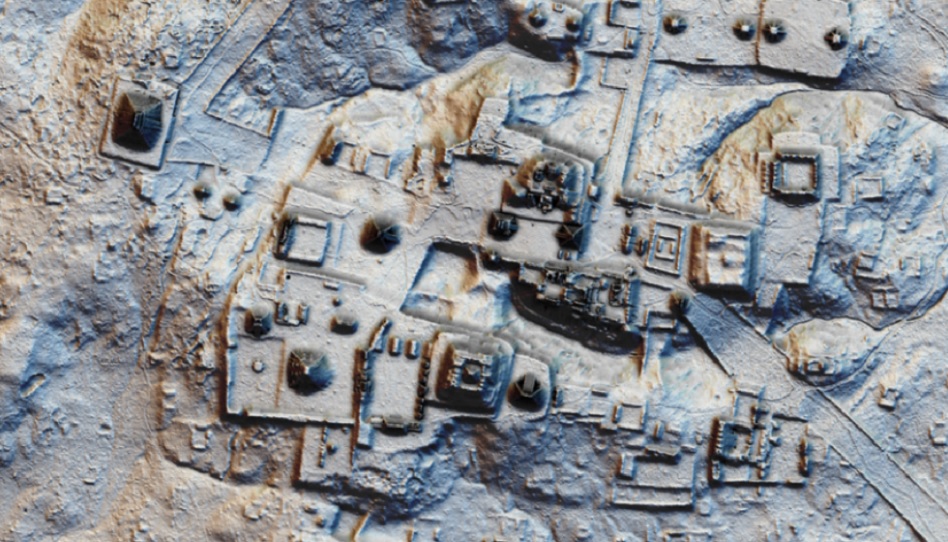
For LDS researchers, that Guatemala data landed like a gift. Writers at Book of Mormon Central pointed out that the lidar findings, dense population centers, industrial-scale farming, land covered edge to edge in settlement, fortification walls, centuries of chronic warfare, line up closely with descriptions scattered through 3 Nephi, Helaman, Mormon, and Alma. This isn’t a new argument built for the lidar era, either. BYU anthropologist John Sorenson had argued for a Mesoamerican setting since the 1980s, decades before anyone flew a laser over the jungle. Lidar added an independent data source that, to believers, seemed to confirm details critics had long dismissed as exaggeration.
 North America’s own mound-building cultures are where the debate gets more contested, even among believers. A minority view within LDS scholarship, the Heartland model, associated with researchers like Rod Meldrum, places Book of Mormon events in the American Midwest, pointing to the Hopewell and Adena mound-building cultures as material evidence. Heartland proponents also point past archaeology, to locations many members consider fixed by revelation.
I am not, by any means, claiming any level of scholorship in this research other than what we know for certain through modern revelation: Adam-ondi-Ahman, a valley in Daviess County, Missouri, is named and located in Doctrine and Covenants 116, and Joseph Smith’s own account of the visit describes finding what he called the remains of a Nephite altar nearby. The Hill Cumorah near Palmyra, New York, where Joseph received the plates, was taught by generations of Church leaders, including Joseph Fielding Smith and Bruce R. McConkie, as the very hill where the Nephite and Jaredite nations fought their final battles. That reading runs against the Mesoamerican model favored by BYU Studies and Book of Mormon Central, and even Hugh Nibley rejected any connection between the eastern mound builders and Book of Mormon peoples. Worth noting is that the Church’s own Gospel Topics essay states plainly that no revelation ever fixed the New York hill as the Book of Mormon’s Cumorah, leaving that identification a matter of tradition rather than settled doctrine. The Church has never endorsed a geography for the text at all.
That internal disagreement points to the honest caveat a piece like this needs. I’ve watched many lectures and videos on the topic from both sides — and both sides make compelling arguments. But while lidar can show that ancient Americans built dense, fortified, agriculturally intensive cities, on a scale nobody credited them with a generation ago, it can’t tell you who those builders were, where they came from, or what language they spoke. On that narrower question, mainstream archaeology and genetics point to ancestors of Native Americans arriving by way of Beringia from Siberia roughly 15,000 years ago, and DNA studies to date haven’t turned up the Near Eastern signature a literal reading of the text would predict. Even the Church’s own Gospel Topics essay is careful here, stating plainly that DNA evidence “cannot be used decisively to either affirm or reject” the book’s historical claims.
That’s probably the right way to hold it. Lidar keeps getting better at finding ancient cities under the canopy, and every new survey adds texture to how sophisticated pre-Columbian America really was, well beyond what nineteenth-century Americans assumed about the continent’s past. Whether that texture supports a specific religious narrative is a question the data alone can’t settle. It can rule some claims in as plausible and others out as implausible, but it can’t cross the gap between “advanced civilization existed here” and “this is the one the text describes.” That gap is still, as it’s always been, a matter of revelation and interpretation, not a topographic match. At least until more evidence is discovered, or more revelation received…